municipal drainage department - cologne
| 3D relief modeling | |
| Data preparation for flood simulation | |
| Interaction | |
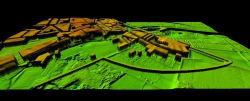
Prior to model production the visibility of many important morphological details had to be clarified which in the relatively flat landscape would possibly be emphasized too little concisely for the planned presentation form. This concerned especially the existing dikes and the populated areas. In a first step, therefore, the very detailed digital elevation model was subjected to a significant vertical exaggeration.
Thus, the trough character of the retention area as an old arm of the Rhine was already more distinctly visible. In a second step, the settlement areas were mapped summarily and superimposed as a block structure with a distinctive profile. Because of the filigree surface features the model was finally printed.
|
above: printed relief model (raw state) Motifs on the left: top: 3D simulation below: Building design - © stEB |